City of Mission staff will be contacting a consultant to begin work on a development plan for the Dunsmuir neighbourhood.
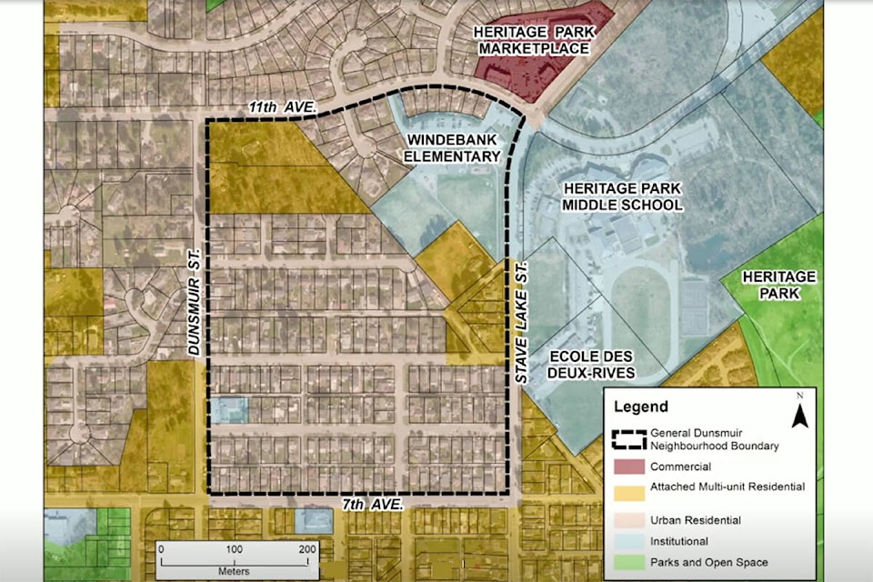
The neighbourhood has been generally defined as 7th Avenue on the southern border, 11th Avenue to the north, Dunsmuir Street to the west and Stave Lake Street to the east, but the exact boundaries are still being refined.
“This is sort of where the critical mass of things are going on,” said Mayor Paul Horn.
Currently, the area is largely made up of single-family residences, but there has been development pressure to create multi family residences and make use of larger lots with older homes.
Residents have raised concern about the development in the area with respect to parking, traffic, privacy, and character.
These concerns came to head last March when a public hearing brought out fierce opposition to an application to develop a 152-unit complex on 10th Avenue and Stave Lake Street.
Council eventually rejected the proposal, even though it had “checked every box” in the Official Community Plan (OCP).
Any outsourced plan developed by consultants will provide guidance on land-use expectation and key policy areas like housing objectives, commercial services, transportation, parks and trails, urban design, environmental protection and community facilities. It will also be accompanied by an engineering plan and financial strategy to accommodate expected growth.
The consultant fees and community engagement for the plan are estimated to cost an estimated $200,000 and take up to a year to complete.
Staff recommended work start by February, 2022, following the completion of their affordable housing strategy and the development plan for the Parr neighbourhood.
The area has been identified as a strategic area for growth for the city in the OCP, along with the Cedar Valley, Waterfront, Hatzic and Silverdale.
Horn said he’s already been speaking with some neighbourhood groups and their development concerns, which include protecting local greenspace and wetlands.
Regarding the previous large development project that failed in the area, he said developers need to realize that adhering to Mission’s OCP is not a guarantee of success.
“Impressing Council, impressing regulatory bodies, impressing staff, those are three quarters of the battle, but the biggest part of it is working with the community and making sure that the community feels comfortable,” he said.
Coun. Danny Plecas was concerned the selected area was too small for a local area plan, and said he would like to see a broader area with natural boundaries included if council invests time and money into a plan.
He also noted that developing a plan for this area comes with potential challenges, as it’s an older neighbourhood with wider streets and no sidewalks.
‘This gives us an opportunity in looking at this neighborhood to say this is a template we can use elsewhere,” Plecas said. “There’s a lot of considerations.”