After months of public consultations, Mission council has approved a rough guiding document for development of its waterfront.
On Dec. 20, they endorsed, by a vote of six-to-one, staff’s preferred land use plan (PLUP) to serve as the basis for the waterfront’s master plan.
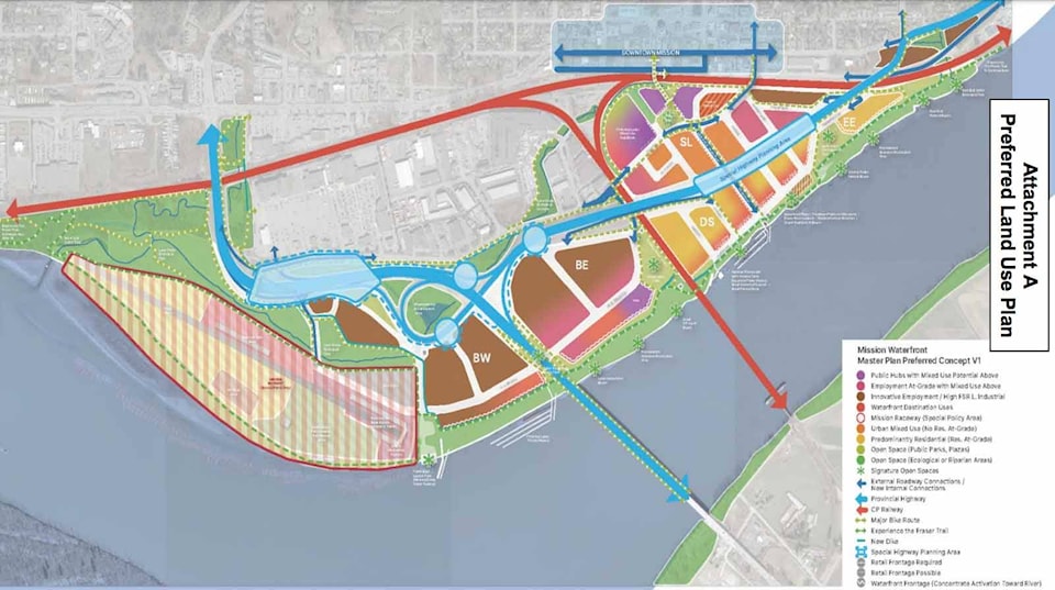
The PLUP will act as the rough draft for land use planning, but may contain “encumbrances, uncertainties and risks that need to be tested” in the future.
Details are subject to change upon review ahead of the final version of the master plan, but the document moves the discussion from “possibilities to probabilities,” said Gerald Schlesiger, project manager.
Mayor Paul Horn emphasized that staff needs to be in continuous consultation with all stakeholders about the plan, and added an amendment to that effect.
‘This is an ongoing and evolving conversation that will need to be done collaboratively. I think that this is a first foray into it,” Horn said.
The five key messages to come out of the public consultations were support the existing downtown, focus on developing employment lands, support pedestrian accessibility to the Fraser River’s banks, support an environmentally friendly relationship to the river, and support more discussions about Mission Raceway Park’s future, according to staff’s report.
The PLUP aims to support the downtown area by creating a pedestrian overpass over the CPR rail tracks to connect Welton and Mershon streets.
The southern foot of the overpass would be a “centralization of hub activities,” transforming Mershon Street into the new Main Street.
Employment lands would be developed west of the CPR Rail Bridge, while lands south of the Highway 11 alignment and east of the rail bridge promote a residential character, and make the dockside and east-end precincts financially viable.
These latter two precincts would serve as a destination place for local and regional visitors.
Mission Raceway Park, representing almost 30 per cent of the nearly 300 acres of waterfront area, would be left status quo at this time. The owners have expressed an interest in potential improvements to reduce noise, and to utilize the land around the year. All residential uses would be developed away from the track.
An infrastructure service plan would improve services to the racetrack to help the owners better utilize, or redevelop the land in the future.
A superdike will be built with the backfill from the new Fraser River sewer crossing, raising all lands between the current dike to Highway 11 to the flood-construction level.
This new dike alignment follows the “Green Shores” principle, which avoids hard-edge barriers and opts for a natural soft shore that will enhance fish habitats.
Approximately five to 10 per cent of the waterfront will be designated parkland.
The lone vote against endorsing the plan was made by Coun. Ken Herar, who said that the Braich family, who are the largest landowners in the waterfront development area, still had concerns.
He brought forward a motion to defer council’s endorsement until further discussions took place. It was defeated six-to-one.
Horn said that he had spoken with the Braich family, and has asked staff to co-ordinate a meeting with them, and it’s one of the reasons he wanted to add the amendment.
“Here’s the thing. We can’t dither,” Horn said. “Simply getting into the muck starting to arm wrestle right now when we don’t have to is very counterproductive for every stakeholder in this enterprise.”